
Unclaimed brand
Free real-time flood map with 12,000+ NOAA river and coastal gauges. Check flood conditions, see forecasts, and join the waitlist for email alerts. No signup needed for the map.
Liking this brand profile? Share this page

Hex Code
Color name
RGB
HSL
CMYK
#2F7098
Astral
47, 112, 152
203, 53, 39
69, 26, 0, 40
#030712
Black Pearl
3, 7, 18
224, 71, 4
83, 61, 0, 93
#FFFFFF
White
255, 255, 255
0, 0, 100
0, 0, 0, 0
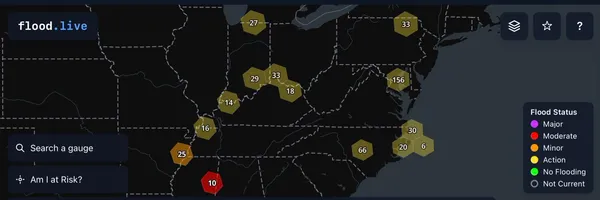
It displays data from more than 12,000 NOAA river and coastal gauges, covering rivers, streams, lakes, and coastal areas. Visitors can search for a city or address, check nearby conditions, and view individual gauge readings, water levels, flood stages, and NOAA forecasts. A clustered map highlights areas experiencing flooding, while optional FEMA flood-zone overlays help users explore long-term flood risk.
The service also offers historical flood-event information and multiple map styles, including satellite, street, dark, and light views. It works in desktop and mobile browsers without requiring an app or signup. Users can join a waitlist for email alerts tied to individual gauges, planned for launch soon.
Gauge data comes from NOAA, flood-zone information from FEMA, and historical events from Google GroundSource. flood. live is intended for information, not emergency decisions; users should follow local authorities and official National Weather Service guidance
Brand industry
Reference Materials
Company type
Suggest company type
Year founded
Suggest founded year
Company size
Suggest company size
How do I download the Floodlive logo?
The Floodlive logo comes in two versions: a logo and an icon. Download as transparent PNG or JPEG.
What are Floodlive's brand colors?
The Floodlive color palette uses the hex codes #2F7098, #030712 and #FFFFFF.
The Floodlive name, logos and brand assets are trademarks of Floodlive and its affiliates. Brandfetch isn't affiliated with or endorsed by Floodlive. Their use is subject to Floodlive's brand guidelines.
