Map Tecch
@maptech.co.nz
Map Tecch provides Drone Surveying, Volume Estimations, Construction Progress Monitoring, 3D Modelling, Roof Inspections, Underground Utility Mapping, Drone Photos & Videos, Cartography and UAV As-Built Maps
Map Tecch's Company Logos

Map Tecch's Brand Colors
Hex Code
Color name
RGB
HSL
CMYK
#0298E5
Cerulean
2, 152, 229
200, 98, 45
99, 34, 0, 10
#CC9B8A
Eunry
204, 155, 138
15, 39, 67
0, 24, 32, 20
#8E2231
Old Brick
142, 34, 49
352, 61, 35
0, 76, 65, 44
About Map Tecch
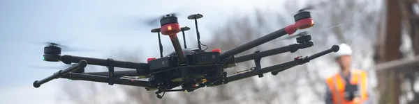
Map Tech Ltd is a New Zealand-based company that specializes in capturing data and information using state-of-the-art drones or UAVs (Unmanned Aerial Vehicles). Led by founder Abhi Chaves, a highly skilled professional with a background in geology and earth sciences, remote sensing, and GIS, the company is known for its innovative and problem-solving approach. With expertise in GIS, drone surveying, mapping, and remote sensing, Map Tech offers a range of services to clients across various industries.
These services include stockpile and excavated volume estimation, roof inspections, GPS and drone surveying, drone technology solutions, digital utility mapping, 3D fly-throughs, asset information management, and aerial photography. Map Tech's groundbreaking research and innovative mindset have earned them accolades from clients, who view them as trusted problem solvers and experts in the field. Their drones have been flown over various locations such as golf courses, construction sites, industrial and residential sites, warehouses, traffic intersections, and quarries.
For all your data and information capturing needs, Map Tech Ltd is your go-to solution, offering nationwide operations and a commitment to using cutting-edge technology to address real-life challenges faced by professionals. Contact them at info@maptech. co.
nz or call (+64) 27 356 3960
Company type
Privately Held
Year founded
2018
Company size
2-10 employees